West Area

Functional Uses
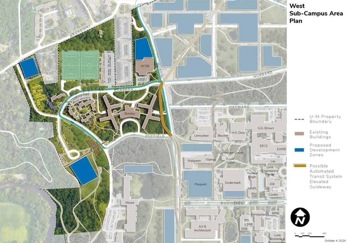
The West Area is the northwest area of North Campus. It is surrounded by private housing to its north and west and bound by Broadway Street, Duffield Street, Baits Drive, the Huron River, and Murfin Avenue. Characterized as a “campus in the woods” its residential, recreation, and support facilities offer views of the Huron River Valley, the Medical Center Campus, and downtown Ann Arbor. Uses represented in the West Area include housing, and student recreation fields and facilities.
Development Opportunities
The West Area is designated for long-term redevelopment. The southernmost Baits I site offers a significant redevelopment opportunity given the potential views of the Huron River Valley and Ann Arbor to the southwest and should be reserved for a special and unique use. Expansion of the North Campus Recreation Building (NCRB) serves a portion of the projected increases in residential and daytime population on North Campus. The Stearns Building site near Broadway offers an opportunity for redevelopment. While not indicated in the 25-year plan, in the long term the Bursley Hall site could be redeveloped, including a major facility along Murfin Avenue.
Landscape and Public Realm
Redevelopment provides the opportunity to establish a new landscape and open space structure for the West Area, reinforcing the wooded nature of the context while potentially opening up views over the Huron River Valley from the Baits I redevelopment site. Overall, the wooded character is maintained in support of health and well-being. Future site and planning should be responsive to the topography and universal access goal. New trails in existing woodlots will require increased forest management to ensure safety of users and successional planning of the natural features. Two recently completed recreation fields on Hubbard Street offer future opportunities to continue building this area of North Campus as a valuable student destination and can serve as a venue for a variety of campus purposes in the future.
Mobility and Connectivity
The pathway network envisioned for the West Area includes routes along Murfin Avenue, Duffield Street, and Hubbard Street linking to the existing trail system in the wooded areas along the west edge of North Campus. That system of trails situated along steep slopes near the Huron River provide the potential for an enhanced amenity linking campus to Cedar Bend Drive and Fuller Road to the south, and to the city’s Island Drive Park to the west. There is potential to facilitate non-motorized connectivity to the elevated Baits I redevelopment site navigating the steep slopes from Duffield and Baits Drive. The pathway and trail network provides connections to the School of Music, Theatre & Dance facilities in the Core Area and to the Innovation District to the northeast. A proposed BRT loop is proposed along Hubbard Street, Baits Drive, and Duffield Street.
Sustainability and Infrastructure
Geo-exchange bores should be considered as feasible in the future landscape structure of the West Area, along with including solar PV where prudent on future buildings and assessing their feasibility on existing buildings. Stormwater management best practices should be followed and other strategies to build resiliency for future ecological conditions should be considered, including enhancing biodiversity.
Next Up:
-

Central Core - Gerstacker Grove
The Central Core Area-Gerstacker Grove is bound by Hubbard Street, Murfin Avenue, Bonisteel Boulevard, and Beal Avenue.
-

Central Core - South of Bonisteel
The area south of Bonisteel is defined by Fuller Road on the south, Bonisteel on the west and north, and the Arborcrest Cemetery on the east.
