Mitchell Field

Functional Uses
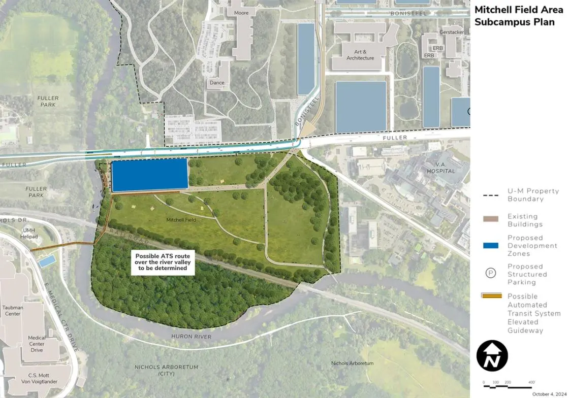
Located in the Huron River Valley, the Mitchell Field Area is south of the Central Core Area and is generally defined by the Huron River on the south and west, Fuller Road on the north, and Fuller Court on the east. A railroad divides the area, isolating the wooded undeveloped parcel to the south. Home to recreation fields, support facilities, and parking, the units represented in the Mitchell Field Area are Student Life and surface parking. It is viewed as a significant area within the river valley open space network.
Development Opportunities
The framework plan identifies an opportunity for development along the Fuller Road edge near the river, potentially for housing, and integrated with a new riverfront amenity zone. Proposed integrated parking and ground-floor active uses contribute to the vitality of Fuller Road. No development is proposed for the parcel south of the railroad and north of the river given it is currently landlocked and within a flood zone.
Landscape and Public Realm
The existing recreation fields and parking on Mitchell Field are envisioned to be replaced over time with wooded and naturalized areas for passive recreation by users from both North Campus and the Medical Center Campus via the proposed pedestrian bridge. This planned relocation will provide an opportunity to integrate views of the Huron River Valley into the campus experience, visually connecting the Arb, the Medical Center Campus, and North Campus.
A proposed pedestrian and bicycle bridge over the Huron River and railway provides opportunities to accentuate views northeast of the Lurie Tower on North Campus and the Huron River.
A proposed riverside terrace near Fuller Road allows for access for river-related recreational purposes, integrated with and supported by adjacent new building development.
Mobility and Connectivity
The framework plan highlights the Mitchell Field Area as an important open amenity space and connection between the Medical Center Campus, Central Campus (the Arb), and North Campus. This is achieved by means of a proposed pedestrian and bicycle bridge over the Huron River and railway connecting the Arb and the Medical Center Campus to Mitchell Field. A passive open-space environment south of Fuller Road links to the Arb and the Gallup Park Pathway network by means of an underpass under the railway. Combined with the bridge and underpass links, Mitchell Field serves as the connection between North, Central, and Medical Center campuses.
A proposed BRT route and potential stop on Fuller Road provides connections to North Campus and back to the Medical Center Campus and Central Campus. The possible ATS elevated guideway crosses the Mitchell Field Area but does not include a stop given the likely height of the guideway through this section. The existing shared-use path along Fuller Road is identified for potential rehabilitation and widening, in coordination with planning supporting the Washtenaw Border-to-Border Trail. No specific alignment for possible ATS has been confirmed.
Sustainability and Infrastructure
Mitchell Field includes over 30 acres of land designated for geo-exchange bores and ground source heat pumps to supply the energy needs of proposed development and partial needs for the Medical Center Campus and possibly portions of North Campus. The proposed pedestrian bridge could be used as a potential utility connector to the Medical Center Campus. Integrated solar PV is recommended for all future construction along Fuller Road.
Next Up:
-

Glazier Way
The Glazier Way Area is bounded by Glazier Way on the north, Fuller Road on the south, the VA Hospital to the west, and private residences and a public school to the east.
