East Area

Functional Uses
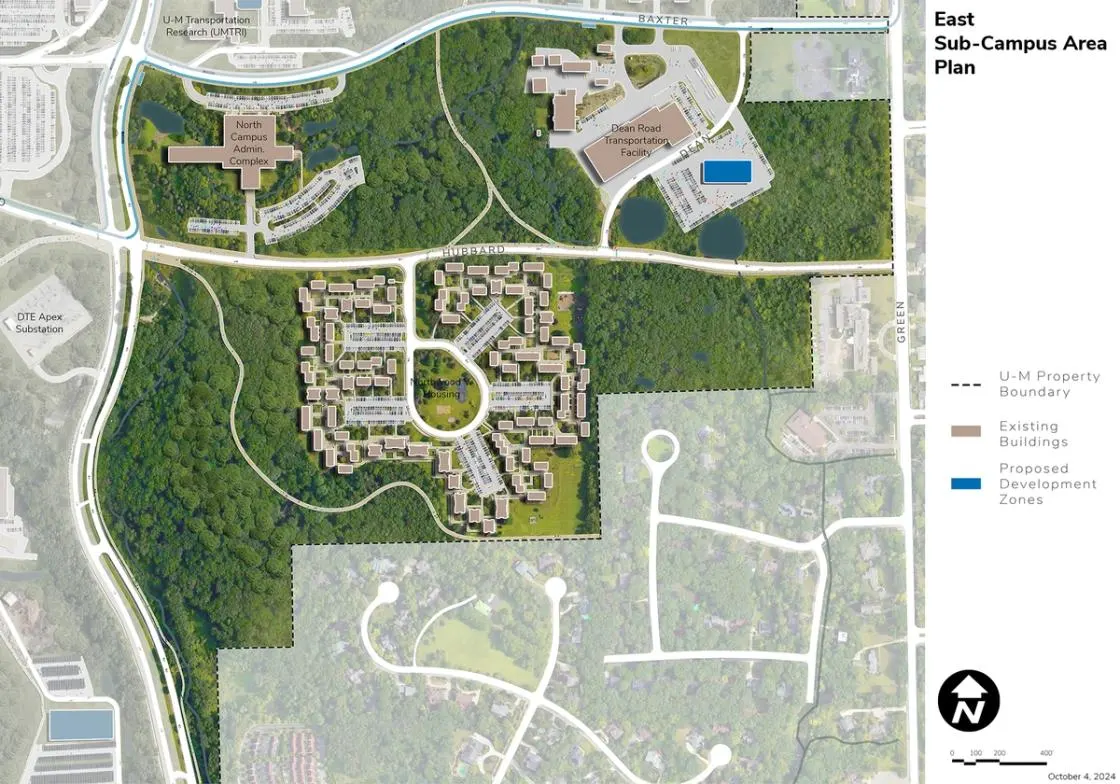
The East Area is located south of the Northeast Area. It is bound by Baxter Road, Huron Parkway, Green Road, and private housing to the south. Facilities include family housing, support, grounds, and administrative uses. The units included within the East Area include Student Life, Michigan Medicine, and other support functions.
Development Opportunities
With minimal planned redevelopment, the East Area focus of the plan will include continued reinvestment in Northwood V housing to support the needs of families with children. This complex is an important housing complex within the Student Life portfolio and should be considered for reinvestment and potential capacity expansion including densification. It’s expected that a new facility for Fleet Services will be developed near the Dean Road Transportation Facility and Baxter Road and is expected to accommodate the displacement of facilities in the Kipke Drive Area of the Ross Athletic Campus.
Landscape and Public Realm
Green buffers are maintained between university and adjacent land uses where appropriate, and in support of human health and well-being; democracy, civic, and global engagement; and environmental justice, the introduction of additional food production gardens is recommended within the existing outdoor spaces or on adjacent land near Northwood V housing. Views into the central green space of Northwood V should be preserved and enhanced over time. There is the opportunity to introduce additional recreation trails through wooded areas as an additional campus amenity, promoting health and well-being.
Mobility and Connectivity
The relocation of Fleet Services to the Dean Road area supports the overall strategy of co-locating university transit operations and support. Additional trails, sidewalks, and bike facilities should be considered, as both well-being and to facilitate nonmotorized connections.
Sustainability and Infrastructure
The integration of geo-exchange bores and ground source heat pump fields is proposed in the existing central open space defined by the Stone Road loop and under existing surface parking lots. This should coincide with reinvestment in the Northwood V buildings and their conversion to more energy efficient systems to take advantage of geo-exchange and ground source heat pump capacity. Stormwater management should be integrated as appropriate as part of the geo-exchange and ground source heat pump installation, and opportunities to continue to improve the quality of Millers Creek throughout this area should be explored.
Next Up:
-

Mitchell Field
Located in the Huron River Valley, the Mitchell Field Area is generally defined by the Huron River on the south and west, Fuller Road on the north, and Fuller Court on the east.
-

Glazier Way
The Glazier Way Area is bounded by Glazier Way on the north, Fuller Road on the south, the VA Hospital to the west, and private residences and a public school to the east.
