Innovation District

Functional Uses
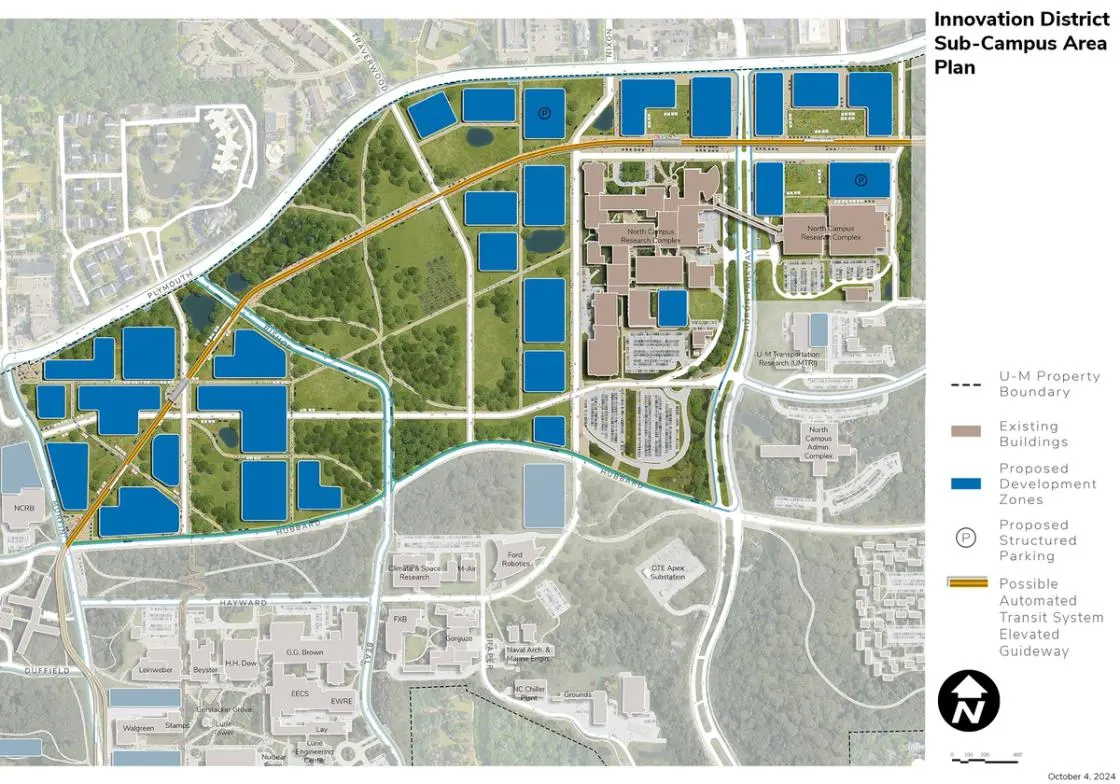
The proposed area for the Innovation District is located in the north-central section of North Campus. It is bound by Plymouth Avenue, Murfin Avenue, Hubbard Street, and Millers Creek, east of the North Campus Research Complex. Existing uses in the Innovation District include the 28 buildings and 2.1 million square feet of the North Campus Research Complex (NCRC), which includes research buildings, utility plants, a solar PV array along Plymouth Road, as well as a parking structure and several large surface parking lots. The area also includes low-density housing areas known today as the Northwood Apartments I, II, III, and IV. Other uses include housing community centers, the North Campus Children’s Center, and the City of Ann Arbor’s Fire Station 5. The area is also characterized by areas of quality woodlots and mature trees drifting over gentle changes in topography throughout the existing low-density Northwood housing areas.
Campus Plan 2050 enhances NCRC by establishing a new gateway defined by a hotel and conference center and possible ATS and BRT station at the southwest corner of Huron Parkway and Plymouth Road. The hotel and conference center would bolster U-M’s collaboration and partnership goals, while enhancing the vibrancy and amenities of the Innovation District, which encompasses the NCRC and land in the Northwood area to the west. The possible ATS and BRT station and services link the NCRC and the hotel/conference center to various academic and research activities across North Campus, the Medical Center Campus, and Central Campus.
Development Opportunities
The proposed framework plan for the Innovation District introduces a grid pattern of streets to structure the public realm and guide future development. This framework designates proposed development parcels to support a variety of land uses, including academic, research, innovation, partnership, residential, and amenities. The aim is to offer a flexible structure that can adapt to U-M’s evolving needs and priorities over time.
In creating the Innovation District, the framework plan is further shaped by the following aspirational ideas identified during the planning process:
- Welcoming Spaces: The Innovation District is envisioned as a welcoming and universally accessible environment designed to engage the broader campus community. New spaces that support U-M’s focus on democracy, civic engagement, and global involvement are recommended throughout the Innovation District.
- Accessible, Pedestrian, Bike, and Transit Oriented: The Innovation District is envisioned as a universally accessible environment with well-designed pathways, bike routes, and integrated transit station. Major destination facilities and amenities are clustered around the possible ATS and proposed BRT transit station to enhance the user experience.
- Public Realm: A vibrant and dynamic public realm is envisioned throughout the Innovation District, featuring transparent and active ground floor uses, the integration of art and cultural facilities, and a range of amenities for a broad population of users, including residents.
- Aesthetic Expression: Facilities in the Innovation District should be inspirational and creative. New structural systems such as mass timber should be considered along with new facade materials that improve building envelope performance. Emphasis should be placed on innovation in architectural expression, materiality, and experience showcasing U-M’s research. The overall aesthetic should be contemporary and reflective of the specific programs proposed for the buildings.
- Density: A higher density of development should be encouraged in the Innovation District with taller buildings along Plymouth Road in response to the increase in density proposed by the City of Ann Arbor. Higher density is needed to support the range of amenities and services envisioned for a walkable, transit-oriented environment. A range of uses within buildings should be promoted with residential facilities stacked above as feasible. Lower-level or below-grade structured parking should be considered in strategic locations with other uses stacked above.
- Climate Response: Buildings in the Innovation District should be carbon neutral, high-performance structures that help meet U-M’s climate action goals and objectives. Solar PV, geo-exchange bores, and ground source heat pumps should be integrated in the buildings and the landscapes. Buildings and open spaces should consider Michigan's climate with south facing and buffered outdoor spaces.
- Open Space and Landscape: The open space and landscape structure of the Innovation District should be responsive to the existing natural features. It should integrate new open spaces to provide greenery, access to and integration of nature, and opportunities for social gathering and recreation. The landscape should be aesthetically pleasing and functional, integrating geo-exchange and ground source heat pumps and stormwater management infrastructure. Accessible pathways and bike lanes should be integrated for connectivity and in support of the health and well-being goals of U-M. Existing high-quality trees and wooded areas are shown as preserved, managed, and united in a cohesive central green amenity open space extending from Hubbard Street to and along the Plymouth Road edge, with circulation pathways strategically integrated connecting major destinations and following existing topography and open space.
- Integrated Arts, Humanities, and Technology: The Innovation District is envisioned to integrate new opportunities for the arts and creative expression. Galleries, performance areas, and public art should be integrated at key destinations, at transit stations, and in public spaces. Technology should be integrated to manage the environment and to support the academic and research activities of U-M.
In addition to the aspirations outlined above, specific development opportunities are identified in the plan around the existing North Campus Research Complex (NCRC). The east area of NCRC is transformed to establish a Innovation and Research Hub. The site’s proximity to an array of academic and research programs on North Campus represents a tremendous opportunity to expand U-M’s innovation ecosystem. If completed as envisioned, the Hub aims to catalyze research commercialization, entrepreneurship, and external partnerships, serving the people of Michigan and the global community. Located in a grouping of buildings proposed for the southeast corner of the Huron Parkway and Plymouth Road intersection, the Hub is envisioned as a key element in the broader Innovation District intended to foster interdisciplinary and collaborative research, and increase density, vitality, and activity in the North Campus area. Existing lowrise buildings are shown for possible redevelopment to further support research partnerships and strengthen collegiality.
The Research and Innovation Hub will offer space for public-private partnerships, startup and accelerator functions, and a variety of partner tenants. Programs range across U-M strengths in health sciences, therapeutic discovery, bioengineering, mobility, and energy technologies and more.
Campus Plan 2050 calls for continued investment and utilization of NCRC west of Huron Parkway in support of the research mission. Future planning and renovation studies for the existing NCRC complex of buildings should take into consideration opportunities for improving east-west connectivity through the interior circulation routes of the existing buildings to improve more intuitive wayfinding. A new entrance on the west is recommended to connect with the research facilities and housing districts proposed in the Northwood area. Improvements to the southern entrance are also needed. The existing west ring road is shown as being realigned closer to the existing NCRC buildings, creating a stronger north-south circulation spine with development lining its west edges and connecting with the Core Areas and Hayward Street to the south.
Campus Plan 2050 enhances NCRC by establishing a new gateway defined by a hotel and conference center and proposed ATS station at the southwest corner of Huron Parkway and Plymouth Road. The hotel and conference center would bolster U-M’s collaboration and partnership goals, while enhancing the vibrancy and amenities of the Innovation District, which encompasses the NCRC and land in the Northwood area to the west. The possible ATS station and services link the NCRC and the hotel/ conference center to various academic and research activities across North Campus, the Medical Center Campus, and Central Campus.
Landscape and Public Realm
The proposed location of the Innovation District is characterized by the significant wooded areas and trees of Northwood. The framework plan aims to integrate these natural features as much as possible, including the Hubbard/Hayward wooded area between the Innovation District and the Central Core Area. The proposed landscape and public realm of the Innovation District are shaped by the grid pattern of the framework plan and include the following:
- Diagonal Spine: A diagonal corridor following the proposed ATS alignment creates a vibrant route through the Innovation District featuring ground-floor amenities and support services, well-designed accessible pathways, bike lanes, and landscape areas with integrated stormwater management. It will also include geo-exchange and ground source heat pump systems, along with a utility corridor.
- East-West Spine: An accessible pathway will connect a redesigned campus gateway at the southeast corner of Murfin Avenue and Plymouth Road to a possible ATS transit station and extend eastward to the NCRC. The pathway is planned to curve northeast, linking to an existing west entrance of the NCRC. Designed as a landscape corridor, it will feature pathways, bike lanes, and integrated stormwater infrastructure. Additionally, it will serve as a corridor for geo-exchange and ground source heat pump systems, as well as other utilities.
- Open Spaces: Several major open spaces define the land use pattern, each designed to enhance the campus’s vibrancy and amenities. These spaces integrate geo-exchange and ground source heat pumps, as well as stormwater management features, contributing to the functionality of the Innovation District. These spaces include:
- A north-south open space serves as a gateway to the Innovation District from the established academic core to the south. This area functions as the central green space for the smaller district surrounding the possible ATS station.
- Green spaces next to new developments on the west side of the NCRC will serve as amenities while also accommodating geoexchange and ground source heat pumps, as well as stormwater management areas.
- Wooded Corridor: The trees along the ridgeline running diagonally from Hubbard Street to Plymouth Road are preserved and consolidated in the plan. This strategy aims to connect the wooded area between Hubbard Street and Hayward Street with the wooded areas to the south and Leslie Woods to the north of Plymouth Road.
- NCRC: As a former corporate campus, the NCRC does not have the typical “collegiate-like” open space layout. The internal courtyards between buildings offer visual connections to nature and small outdoor seating areas. The development of the hotel and conference facility, along with the possible elevated ATS guideway and station, offers an opportunity to create a new gateway landscape experience. Redevelopment will increase density, improve vibrancy and walkability, and create positive emphasis on the civic realm.
Landscape Development Opportunities
Within development parcels, small courtyards or open spaces provide greenery and access to nature for building occupants. Recommended for large academic, research, and housing buildings, these spaces should support small gatherings with a mix of green and hardscapes. Geo-exchange and ground source heat pumps, along with stormwater management infrastructure may be included. Courtyards should feature public art, event areas, amenities, and connections for utilities.
Landscape Corridors and Circulation
Major pathways, streetscapes, and circulation routes shape the open space and landscape character of the Innovation District. Defined by adjacent architecture, these routes serve as essential circulation and activity corridors. They should prioritize accessibility, pedestrian movement, and emergency and service access. Paving surfaces must be both attractive and durable to accommodate emergency access.
A blend of landscape and hardscape is recommended, considering access to utility easements and integrating stormwater management and geo-exchange and ground source heat pump infrastructure. Lighting, banners, signage, and wayfinding elements should be seamlessly incorporated, along with benches and other site furnishings that do not obstruct flow. Seating should cater to those with mobility impairments.
North-south connections should integrate enhanced corridors from the Central Core Area, including the circulation spine from Fuller Road through Gerstacker Grove, the Hubbard-Hayward woodlot, Beal Avenue, a realigned Hayward Street, and areas near the possible ATS station up to Plymouth Road.
In residential areas, small community gardens are proposed to support social engagement, health, and well-being at U-M. To minimize carbon footprint, traditional in-ground gardening is encouraged over raised beds or greenhouses. These gardens aim to allow campus residents to grow their own food and foster social interaction. Large-scale food production for the broader campus is not encouraged due to its costs, carbon emissions, labor requirements, and land availability.
Mobility and Connectivity
The framework plan for the Innovation District prioritizes accessibility and promotes pedestrian, bicycle, and transit mobility over single-occupancy vehicles. The proposed grid layout seamlessly integrates these modes of transport across the district, providing a range of flexible mobility options for users. Interior areas are dedicated to human mobility, featuring key corridors such as the Diagonal, NorthSouth, and East-West spines, as well as pathways within each grid block.
The framework plan incorporates the possible ATS guideway and two stations: the Innovation District Transit Station (IDTS) and the NCRC Transit Station (NCRCTS). Significant destinations and public art and amenities are planned around each station; for example, the NCRCTS is situated next to the proposed hotel and conference center at the NCRC.
The grid layout is shaped by a series of “complete” streets, designed to accommodate accessible pathways, bike lanes, and proposed BRT services, while limiting vehicular movement to the grid’s street pattern. Parking structures, including potential underground or lower-level parking, are integrated into future development sites, with a focus on peripheral locations along Plymouth Road.
Pathway and bike connections are extended to adjacent sub-campus areas, including the West Area and the Central Core. New accessible routes through the Hayward-Hubbard woodlands facilitate connections to the Central Core, with a major route leading to the Leinweber Building at accessible slopes.
The framework plan also includes enhancements along Plymouth Road to support the city’s Transit Corridor designation, potentially incorporating a dedicated bus lane. Bus routing and bike facilities are suggested along Hubbard Street. McIntyre Street will be realigned to provide an alternative north-south road intersecting Plymouth Road.
Potential modifications to Huron Parkway could accommodate bus-only lanes, as well as a new crosswalk south of the Plymouth Road intersection to link the hotel and conference center with the proposed Research and Innovation Hub. An enhanced west entrance is proposed to connect with the Innovation District to the west.
Sustainability and Infrastructure
Geo-exchange bores and ground source heat pumps are proposed across major open spaces in the Innovation District, along the possible ATS and landscape corridors, and within individual development sites. These zones should be interconnected when feasible, potentially linking to the Core Area, to create efficient and comprehensive systems that optimize system capacity.
New stormwater management features are also proposed throughout the Innovation District, including within each open space. These should be integrated with the geo-exchange and ground source heat pump systems. Stormwater elements should be designed as visual amenities wherever possible, utilizing the area’s northward-sloping topography toward Plymouth Road to manage runoff from redevelopment. The eastern portion of the NCRC, near Millers Creek, should receive particular attention for stormwater management.
Utility corridors will be defined by the proposed grid layout, including the diagonal and east-west spines. Solar PV installation is recommended for all future construction, especially on parking structures, to support U-M’s climate action goals. Additionally, promoting biodiversity should be a key consideration in planning new and renovated green spaces.
Next Up:
-

East Core
The East Core Area is bound by Hubbard Street, the walking paths connecting Hayward Street to Hubbard Street, Beal Avenue extending northward, parking lot NC-19, and Huron Parkway.
-

Draper Road
The Draper Road Area is defined by Glazier Way on the south, Huron Parkway on the east, and the edge of the privately owned Arborcrest Cemetery to the west.
