Hill

Functional Uses
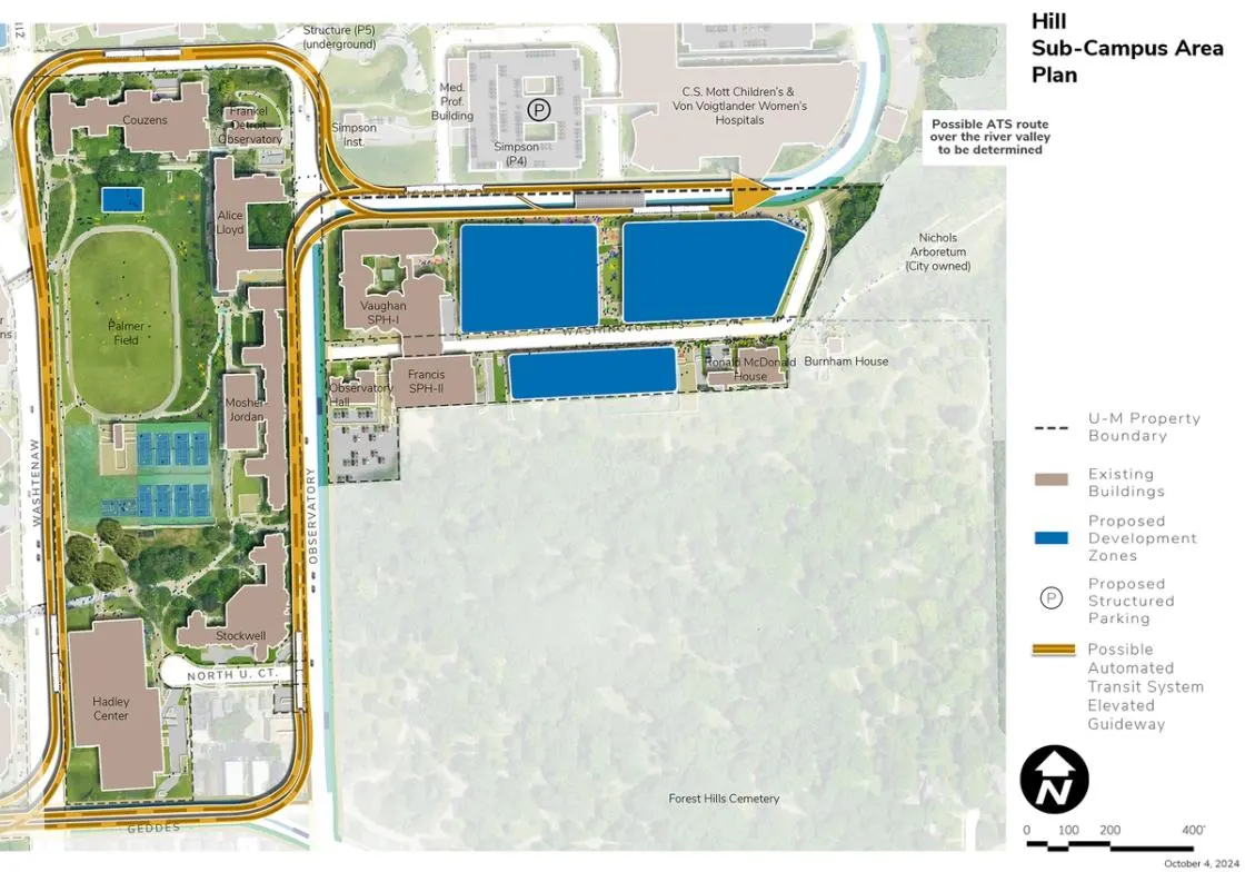
The Hill Area is located at the northeast corner of Central Campus adjacent to the Medical Center Campus. It is generally bound by East Ann Street, Washtenaw Avenue, Geddes Avenue, and Observatory Street. The Hill Area includes student life, housing, dining and recreation, and academic use facilities in support of student engagement and health and well-being goals. The units represented within the Hill Area include Student Life, the School of Public Health, military officer education programs, and the Bentley Historical Library, which oversees the Frankel Detroit Observatory.
Development Opportunities
Potential future demolition of the Mary Markley Residence Hall would free up land for academic research and clinical expansion.
Proposed renovation and expansion of academic and research space is planned in response to modernization goals, and to serve potential future requirements and deferred maintenance issues.
The possible ATS and BRT station at this location offers connections to both Central Campus and North Campus units, creating numerous opportunities for the Hill Area to become another central hub for collaboration.
Landscape and Public Realm
Landscape improvements in the Hill Area focus on Palmer Field, where geo-exchange bores and ground source heat pumps are proposed. The installation of the bores allows for subsequent and concurrent improvements to the heavily utilized recreation fields, surrounding pathways, and stormwater management features, enhancing carbon neutrality, sustainability, and health and well-being goals. In support of continuing campus and community engagement opportunities, consideration should be given to the ability of Palmer Field to continue to support largescale events, including those during Welcome Week. As a key campus open space, the views across Palmer Field from all vantage points should be preserved and enhanced.
Campus Plan 2050 envisions the integration of the possible ATS and proposed BRT station with public realm improvements, notably, the north-south landscape and pathway system linking Washington Heights to clinical uses north of East Medical Center Drive. This “corridor” of landscape is envisioned to include amenities supporting the needs of students, faculty, staff, and visitors to the Michigan Medicine facilities. It is also envisioned as a location to integrate public art. The Hill Area also serves as a key campus connection to Nichols Arboretum to the east, specifically the main visitor entrance at the east end of Washington Heights. The view along Washington Heights to this key Arb entrance should be enhanced, potentially incorporating the addition of trees and a more vegetated streetscape. Redevelopment of the Markley site and adjacent areas should include accommodating the ability of visitors to navigate to this key Arboretum access point to enjoy one of the best natural experiences in Ann Arbor.
Mobility and Connectivity
Major mobility and connectivity improvements in the Hill Area focus on the possible ATS and proposed BRT routes along East Medical Center Drive and Observatory Street. These enhancements have the ability to dramatically increase multidisciplinary research and collaboration between faculty and students on Central, Medical Center, and North campuses. The introduction of these systems also allows for the integration of new landscape, accessible pathways, bicycle lanes, lighting, and signage, which will enhance safety and could encourage more cycling. Proposed changes on Observatory include maintaining the existing bike lane and general-purpose traffic lanes and including dedicated bus lanes for each direction of travel, potentially displacing on-street parking in support of enhanced transit and non-motorized mobility. The sidewalk is maintained on both sides of the roadway within the available space with expansion occurring primarily to the west, reducing some of the green space in front of the U-M residence halls located west of Observatory Street. Dedicated bus lanes on East Medical Center Drive from Observatory Street eastward prioritize bus operations while accommodating vehicular traffic associated with visitors and patients. The Medical Center Campus Transit Station (MCCTS) is proposed as part of the street section redesign to accommodate bus lanes. Bus operations in this area could be further enhanced by potential implementation of queue jump lanes and traffic signal modernization. No specific alignment for the posible ATS along East Medical Center Drive and to the north over the railroad and Huron River has been confirmed. In addition, all recommendations along public right of way will require coordination and support from the City of Ann Arbor.
Sustainability and Infrastructure
Proposed geo-exchange bores and ground source heat pumps under Palmer Field and an accompanying new pumping facility at the north end of Palmer Field contribute to decarbonization goals while providing the opportunity to renew the fields, courts, and landscape in response to well-being goals. Renovation of surrounding buildings will be required for energy efficiency upgrades, including the ability to connect with the geo-exchange and ground source heat pump facility. Consideration should be given to interconnecting the geo-exchange and ground source heat pump infrastructure into a broader campus distribution network. An integrated stormwater management facility in the Palmer Field area could further contribute to the functionality of the area. Solar PV installations should be considered on existing and future buildings with flat roofs.
Next Up:
-

West State Street
The West State Street Area is located west of the Diag Area and south of the city’s State Street District.
-

Diag Area
Located in the “heart” of Central Campus, the Diag Area is bounded by North University Avenue, South State Street, South University Avenue, and Church Street.
